Map of the French permanent accelerometric network (Résif-Rap) in April 2021
Carte du réseau accélérométrique permanent français (Résif-Rap) en avril 2021
Résumé
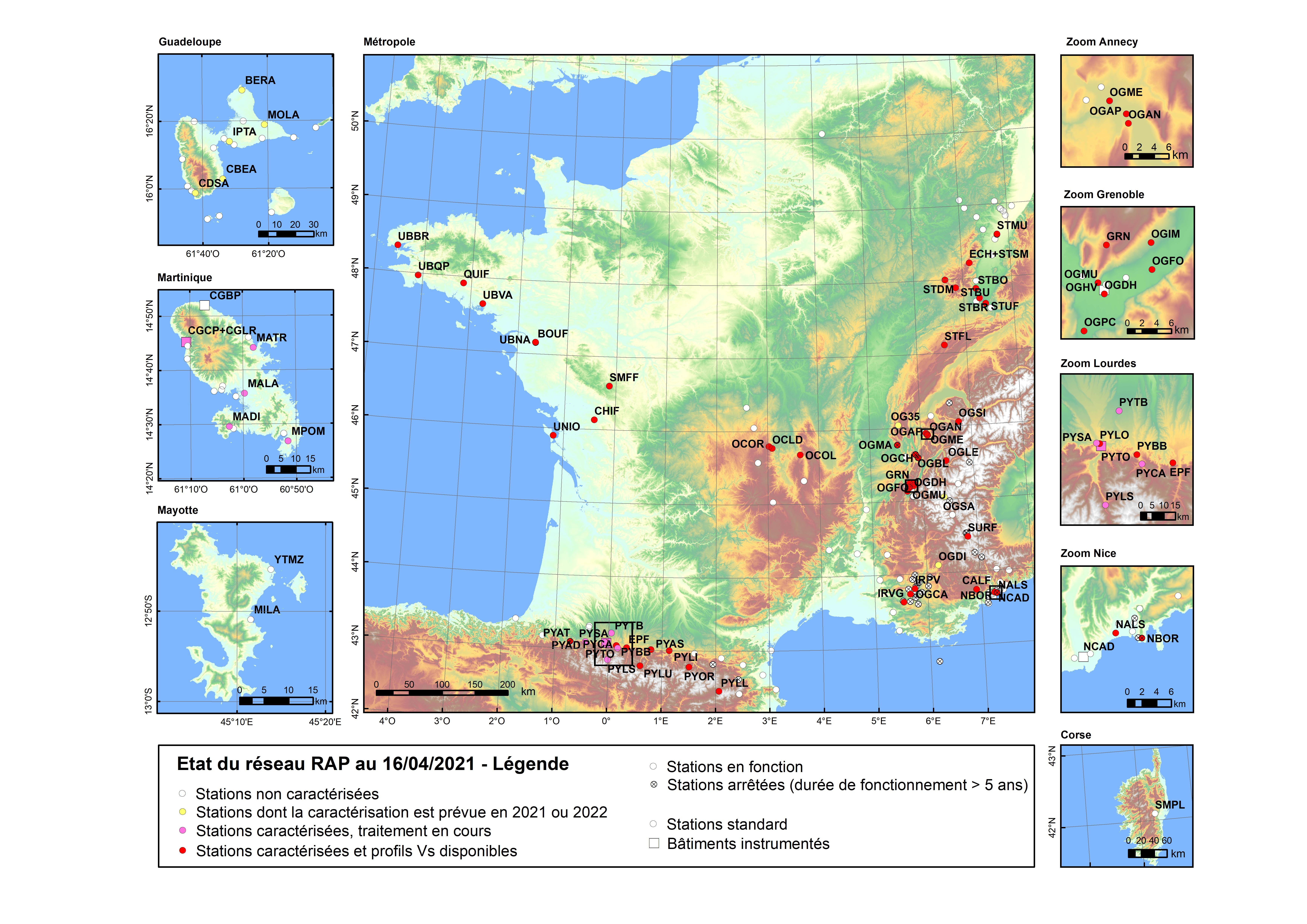
The seismicity map of France shows regions where the seismic hazard is relatively important (Antilles, Alps, Provence Côte d'Azur and Pyrenees) and regions where the seismicity rates are modest but not negligible (Rhine Graben, Ardennes, Massif Central, Massif Armoricain, Mayotte). This seismicity justifies the monitoring of strong ground movements caused by the earthquakes that affect the territory, and their effects on the structures. This is the mission that was entrusted to the Permanent Accelerometric Network (Rap) in 1997 and has led to the instrumentation of 160 accelerometric stations in mainland France and overseas. Accelerometers have the sensitivity required to record high amplitudes without saturation effects in the frequency range relevant to civil engineering. This map illustrates the distribution of these stations in spring 2021.
Rap is part of the French seismological and geodetic network Résif, a national research infrastructure dedicated to the observation and understanding of the structure and dynamics of the Internal Earth. Résif is based on high-tech observation networks, composed of seismological, geodetic and gravimetric instruments deployed in a dense manner throughout France. The data collected make it possible to study with high spatial and temporal resolution the deformation of the ground, surface and deep structures, seismicity on a local and global scale and natural hazards, and more particularly seismic events, on French territory. Résif is part of the European (Epos - European Plate Observing System) and global systems of instruments used to image the Earth's interior as a whole and to study many natural phenomena.
La carte de la sismicité de la France fait apparaître des régions où l’aléa sismique est relativement important (Antilles, Alpes, Provence Côte d’Azur et Pyrénées) et des régions où les taux de sismicité sont modestes mais non négligeables (Fossé Rhénan, Ardennes, Massif Central, Massif Armoricain, Mayotte). Cette sismicité justifie la surveillance des mouvements forts du sol causés par les séismes qui affectent le territoire, et leurs effets sur les structures. C’est la mission qui a été confiée au Réseau Accélérométrique Permanent (Rap) en 1997 et qui a conduit à l’instrumentation de 160 stations accélérométriques en France hexagonale et outre-mer. Les accéléromètres ont en effet la sensibilité requise pour enregistrer de fortes amplitudes sans effet de saturation dans la gamme de fréquences intéressant le génie civil. Cette carte illustre la répartition de ces stations au printemps 2021.
Le Rap est l'une des action du Réseau sismologique et géodésique français Résif, une infrastructure de recherche nationale dédiée à l’observation et la compréhension de la structure et de la dynamique Terre interne. Résif se base sur des réseaux d’observation de haut niveau technologique, composés d’instruments sismologiques, géodésiques et gravimétriques déployés de manière dense sur tout le territoire français. Les données recueillies permettent d’étudier avec une haute résolution spatio-temporelle la déformation du sol, les structures superficielles et profondes, la sismicité à l’échelle locale et globale et les aléas naturels, et plus particulièrement sismiques, sur le territoire français. Résif s’intègre aux dispositifs européens (Epos - European Plate Observing System) et mondiaux d’instruments permettant d’imager l’intérieur de la Terre dans sa globalité et d’étudier de nombreux phénomènes naturels.
Fichier principal
 Carte_2021_Resif_reseau_accelerometrique_permanent_france_V2.jpg (2.63 Mo)
Télécharger le fichier
Carte_2021_Resif_reseau_accelerometrique_permanent_france_V2.jpg (2.63 Mo)
Télécharger le fichier
Origine : Fichiers produits par l'(les) auteur(s)

